Fuel
Vegetation type, amount, arrangement, continuity and moisture determine what can ignite and how much energy combustion can release.
Fire Maps field manual · 4 chapters
Understand how a vegetation fire behaves, what each family of firefighting aircraft can do, how air and ground operations fit together, and what the specialist terms on the map mean.
Educational reference only. During an incident, follow the emergency services, the authorities and the official alerts where you are.

Cross-reference file · quick answers
Each page answers in a few sentences first, then exposes the mechanisms, exceptions, limits and primary sources that make the answer verifiable.
Darkness does not make an aircraft unable to fly. It mainly removes the outside references on which a low-level tactical pass depends, among terrain, smoke and a busy incident airspace.
Read the answerVisibility · smoke · waterAn obstacle can remain present, close and completely real while becoming almost undetectable. The central problem is not only the amount of light: it is the loss of contrast, depth and a dependable horizon.
Read the answerADS-B · coverage and limitsAn ADS-B map represents messages received by a network, decoded and then published. It is neither exhaustive radar nor a register of every mission in progress.
Read the answerSatellite · thermal observationSatellites provide a consistent view across large areas, but every detection carries the time, resolution, angle, cloud conditions and thresholds of the sensor that produced it.
Read the answerDrop · water · retardantProduct, target, height and pass continuity matter as much as volume. A dramatic drop image does not by itself show what effect was achieved.
Read the answerFire behavior · interactionFire responds to local conditions that change over time. A regional wind arrow or danger color is not enough to describe the next movement of the front.
Read the answerReading method · evidenceTwo overlaid colors can appear to tell the same story while coming from completely different times, sensors and methods.
Read the answerChapter 01 · Fire behavior
Wildfire is a moving combustion process, not a fixed object. Its edge changes as heat meets combustible vegetation, local weather and terrain.
Fire behavior emerges from the interaction of fuel, weather and topography. Change one and the same ignition can produce a different spread rate, direction and intensity.
Vegetation type, amount, arrangement, continuity and moisture determine what can ignite and how much energy combustion can release.
Wind, temperature, humidity, drought and atmospheric instability change fuel moisture, flame tilt, smoke movement and the potential for rapid spread.
Slope, aspect, valleys and ridges alter preheating, wind flow, access and escape routes. Fire often accelerates uphill, but local terrain can redirect it.
The fire-behavior triangle: No factor works alone. Wind can dry and tilt flames into continuous fuel; slope can preheat vegetation above the fire; a break in fuel can interrupt both effects.
A wind-driven fire is often described by its head, flanks and rear. Its shape keeps changing with fuels, relief and weather; this diagram is a reading aid, not a prediction.
The most actively advancing part, commonly aligned with wind or upslope spread. It often has the greatest flame length and rate of spread.
The sides between head and rear. They often spread less rapidly than the head and may offer opportunities to build from a secure anchor.
The portion opposite the head. It commonly advances more slowly, but it can remain hot and change behavior if wind or slope changes.
Burning material transported ahead of the main edge can start separate spot fires and defeat an otherwise continuous control line.
A danger index describes how favorable conditions are for ignition and spread over an area. It does not say that a fire exists at a precise location.
A thermal hotspot is a sensor observation or algorithmic alert with a time, footprint and confidence. It is evidence of heat, not a surveyed fire boundary.
A mapped perimeter describes an interpreted or surveyed edge at a stated time. The active front may already have moved, and smoke or resolution can hide detail.
Chapter 02 · Aerial resources
The useful first question is not “which model is it?” but “which mission family is it flying?” The same platform can carry a bucket in one operation and a rescue team in another.
A family describes a usual capability, not the payload, equipment or task of an aircraft at this moment. Configuration, weather, terrain, visibility, water access and incident command decide what can actually be done.
Identify a fleet aircraft
Open the multilingual reference sheets for verified aircraft, grouped by country and mission with silhouettes, registrations, models and operators.
Night operations · safety margin
Aircraft can fly at night. Aerial firefighting is different: scoops, approaches and drops are flown very low in a crowded, changing environment. Daylight is part of the ordinary safety margin.
Daylight
Usual aerial window
Dusk
Command reassesses each mission
Night
Ordinary fleet usually stands down
Dawn
Weather, fire and aircraft checked
Sunset is not a universal timer. Weather, terrain, smoke, crew fatigue, available aircraft and incident command may stop flights earlier or delay their return.
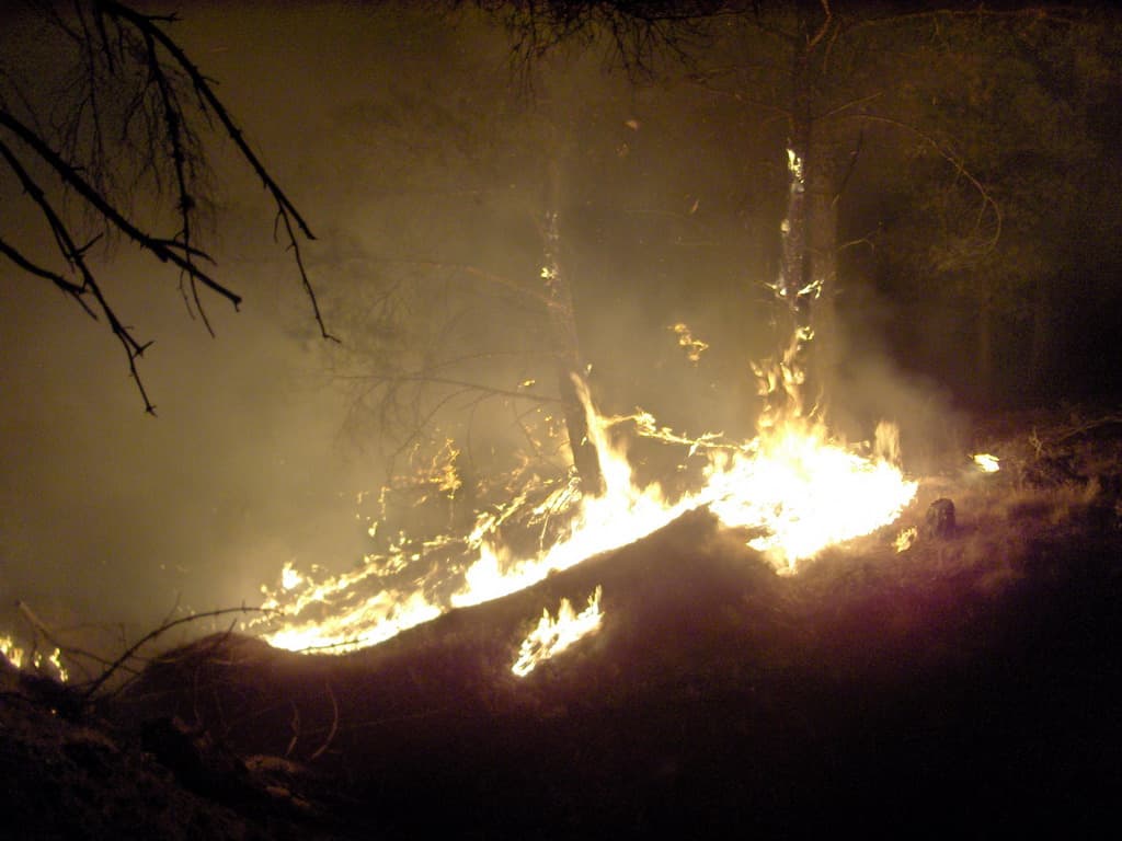
Firelight illuminates fragments, not a usable horizon. Smoke can hide terrain, columns and other aircraft between two bright zones.

On a dark surface, only reflections remain visible. The shoreline, wave relief and floating obstacles can disappear—the cues a scooping run needs.
To aim and then escape, crews must read terrain, trees, wires, the fire edge, smoke and the exit path in time. Darkness reduces contrast and depth cues, leaving less time to react.
An amphibious tanker planes at speed over a long, clear water surface while taking on several tons in seconds. At night, height, waves, shorelines, boats and debris are much harder to judge.
Smoke can mask terrain and traffic, while fire columns, wind and mountain flow can change quickly. Darkness removes outside cues that help crews detect and interpret those changes.
Coordination must sequence passes, keep aircraft separated, confirm that ground crews are clear and maintain a shared picture. Darkness raises the workload for every link, not only the pilot.
Some specially equipped helicopters can reconnoiter or drop water at night. That requires a compatible aircraft, crews qualified with night-vision goggles, mapped hazards, more extensive planning, reliable communications and a dedicated doctrine. Goggles do not reproduce the field of view, depth cues or detail of clear daylight.
It refills while skimming a suitable lake, river, or sea surface, then makes short water-drop rotations when a safe water source is close to the fire. It attacks flames directly with water or foam rather than laying long retardant lines.
Representative types
The turboprop CL-415 family scoops about 6,000 litres in roughly 12 seconds and can divide the load between several doors. It is built for high-tempo direct attack when a safe lake, river, bay, or coastal scoop run is nearby.
It loads water or retardant on the ground and attacks from a runway base. It can knock down flames with water or lay a retardant line ahead of the fire to slow its spread and support crews on the ground.
Representative types

The land-based AT-802 is a nimble single-engine tanker that carries about 3,000 litres. It is suited to fast initial attack and accurate split or continuous drops of water, foam, or retardant, but must return to a base for each refill.
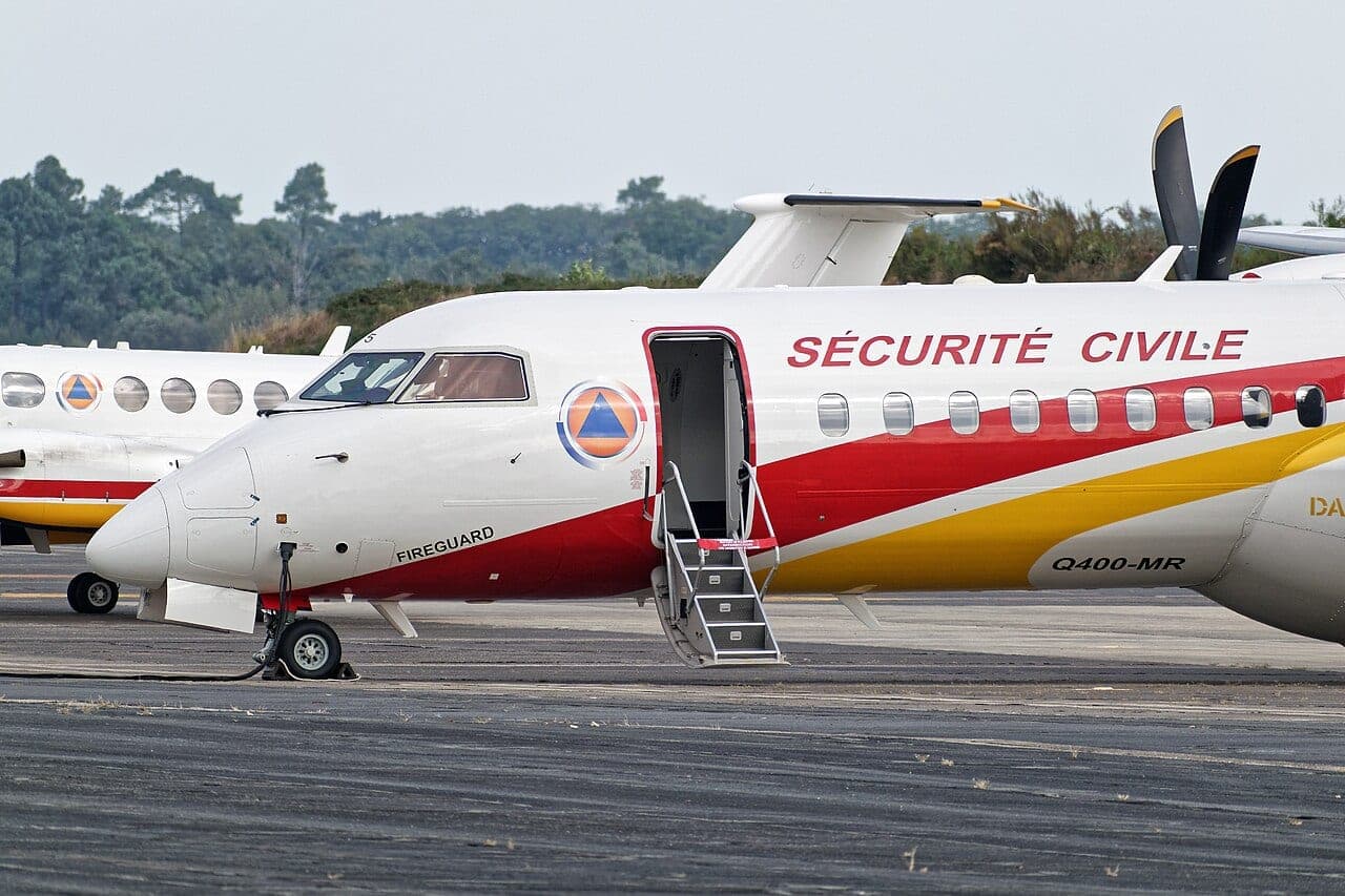
The converted Dash 8-400 combines airliner transit speed with a 10,000-litre constant-flow tank. It can reach distant fires quickly and lay a long, controlled water or retardant line before reloading on the ground.
It uses a suspended bucket or an installed tank to take water from a nearby source and place short, precise drops, including in steep or confined terrain. Depending on its configuration, it may also move crews, equipment, or rescue teams.
Representative types
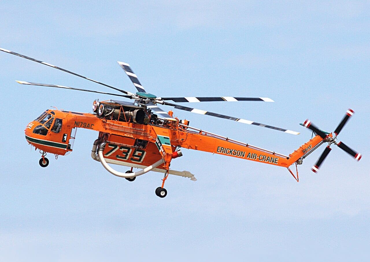
The S-64 Aircrane is a purpose-equipped heavy helitanker with a tank of about 10,000 litres. A hover or sea snorkel can refill it in well under a minute, combining a large load with precise, repeatable drops.
It carries the observers and radios that organize the air operation. It locates and assesses the fire, identifies safe drop runs, separates aircraft in the incident airspace, and guides tankers; it normally carries no water or retardant.
Representative types
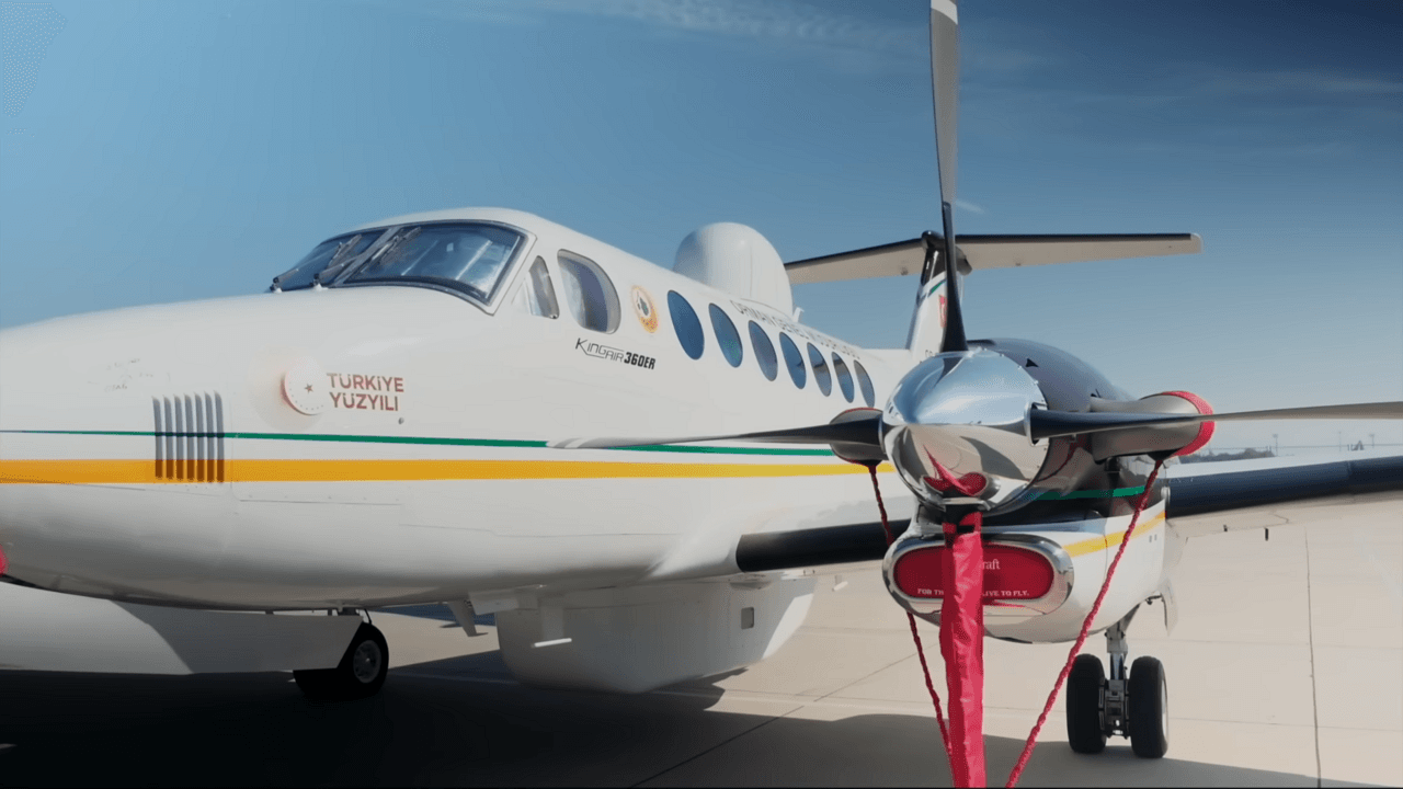
The King Air 350 combines speed, endurance, a pressurized cabin, and room for radios or sensors. It can cover a wide area, map and monitor the incident, and carry the team coordinating tankers and helicopters.
It is tracked here for rescue and operational support, not as a dedicated water bomber. It can reconnoiter, insert or evacuate people, carry medical teams and equipment, and keep command connected when roads are slow or inaccessible.
Representative types
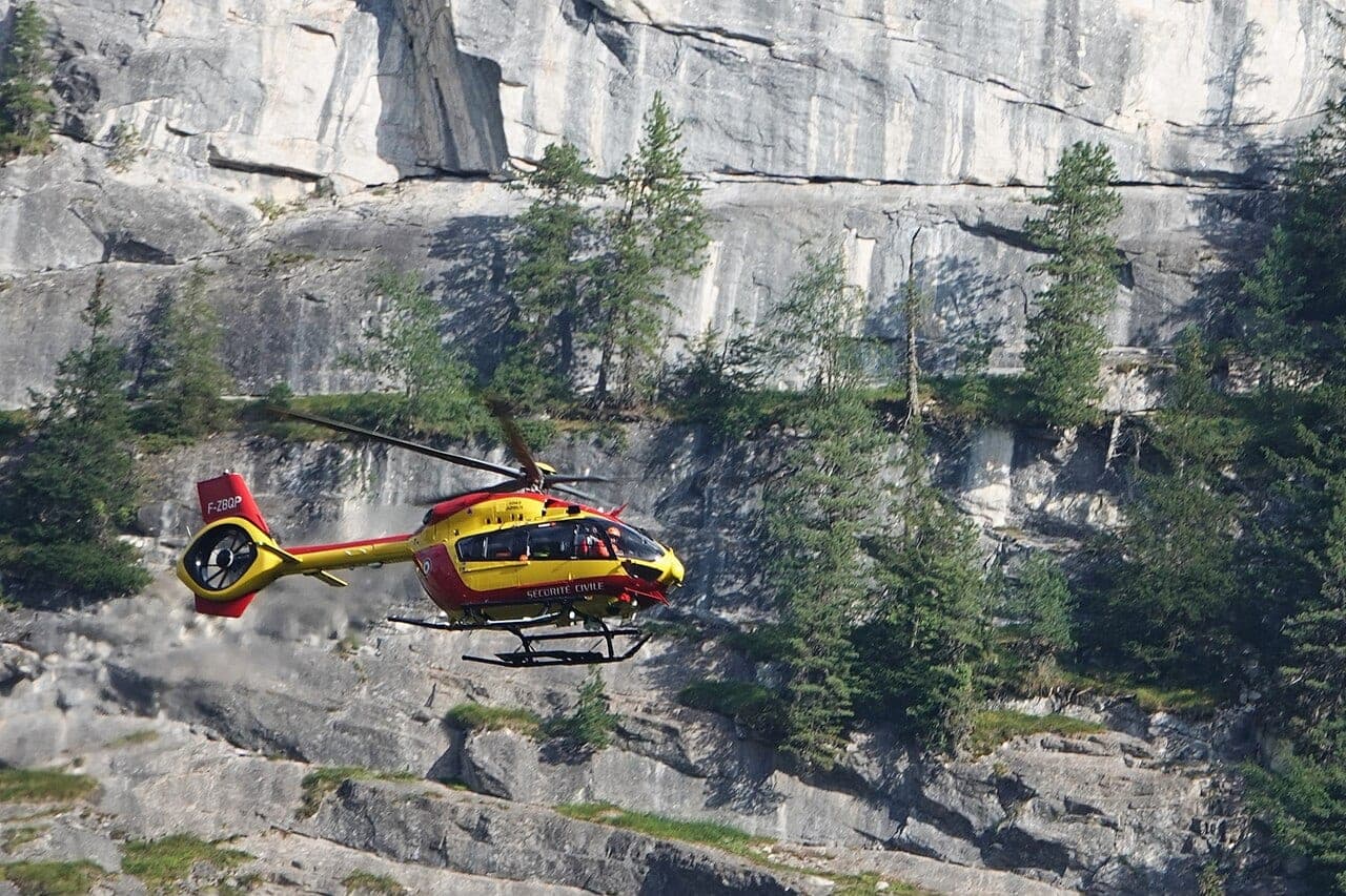
The EC145 or H145 is a compact twin-engine rescue helicopter with a wide medical cabin and access to confined sites. Depending on its equipment, it can carry a medical team, use a rescue hoist, evacuate casualties, and support airborne command.
Chapter 03 · Suppression strategy
Suppression is a coordinated system. Aircraft can cool, slow, mark or observe, but a line becomes defensible only when command, crews and repeated assessment connect the actions.
Aircraft buy time and change local fire behavior; coordinated ground work converts that advantage into a line that can hold.
A simplified sequence showing how evidence, command, aircraft and ground crews connect. Real incidents loop between stages as conditions change.
Calls, cameras, patrols and thermal sensors may reveal heat. Location, acquisition time and confidence must be checked before an alert becomes a working incident picture.
Crews and observers identify the head, flanks, spotting, access, people at risk, weather changes and the limits of each available resource.
Command selects objectives, safety zones, escape routes and a secure starting point so the fire cannot simply work around the beginning of the line.
Air attack sequences runs, checks hazards and places water or retardant where it supports the selected objective while ground personnel remain clear.
Ground crews connect the treated area to a control line, extinguish heat near the edge and patrol for spot fires. This is what turns temporary slowing into containment.
The perimeter, weather and remaining heat are checked again. A controlled fire can escape; an aircraft track or quiet image is never an all-clear.
Command chooses according to current and expected behavior, terrain, resources, values at risk and safe access. These are concepts, never instructions for the public.
Crews and aircraft work at or close to the burning edge. It is precise and avoids leaving unburned fuel inside the line, but requires behavior mild enough for safe access.
A control line follows the fire edge from a short distance. It trades immediate contact for safer, straighter construction while the strip between line and fire is secured.
A line is selected farther from the edge, often using roads, ridges or fuel breaks. It gives room against intense fire but leaves fuel between the fire and line that must be managed under command.
Cross-reference file · quick answers
A circling aircraft, a broken track or a lone red dot can seem to tell an obvious story. These eight answers separate what is observed from what can actually be concluded.
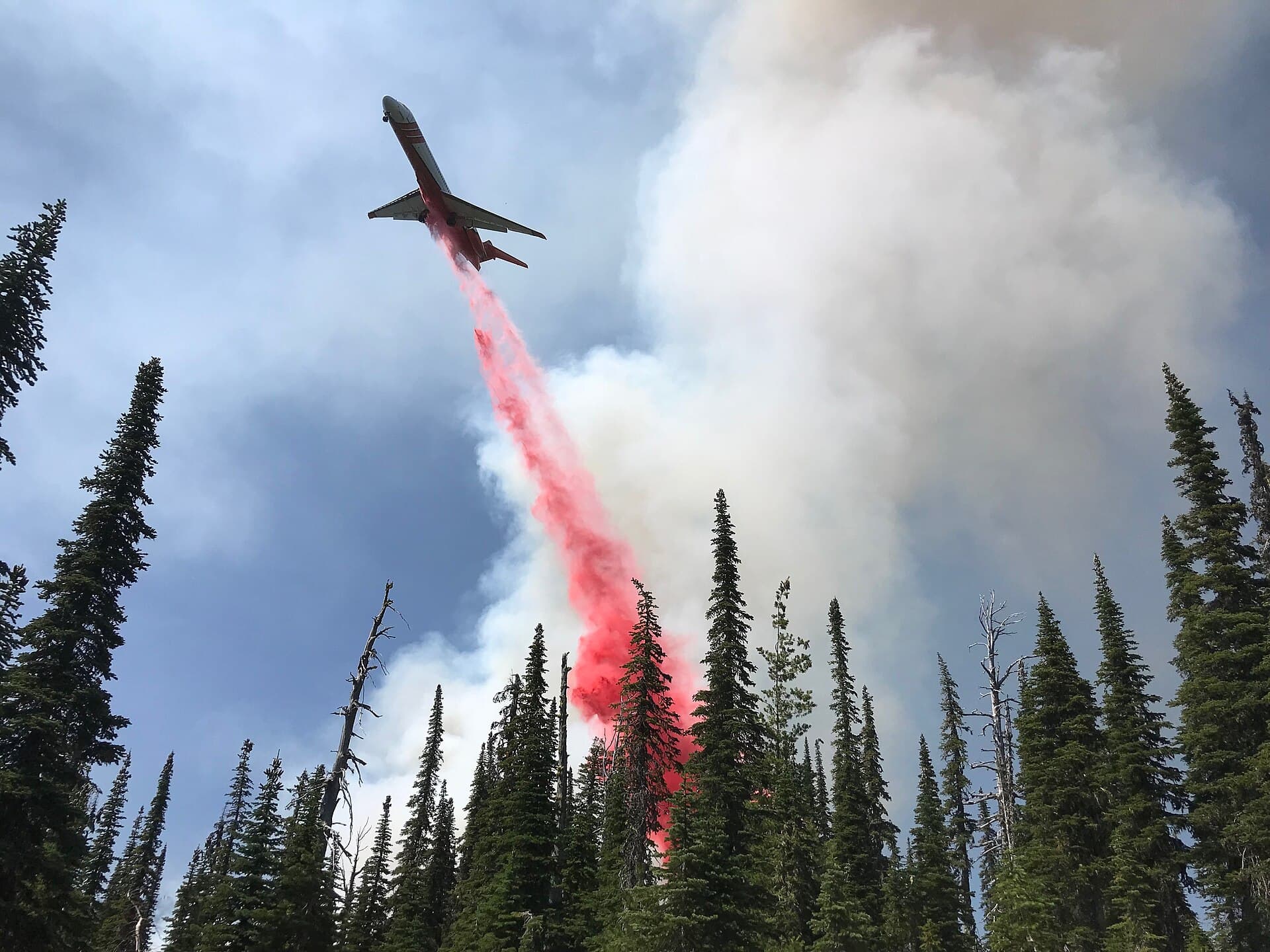
Long-term retardant is not dyed water. Its color helps crews connect passes into a visible line; some colorants later fade in sunlight.
AIR
Short answer
Circling may be the mission, not hesitation.
The aircraft may be mapping the fire, checking smoke, terrain, wires and an escape path, coordinating traffic, or waiting for the target area to be clear and authorized. An orbit alone proves neither the aircraft’s role nor its mission.
Short answer
They buy time; ground crews turn that time into containment.
Water and retardant cool or slow a local area, but their effect can be bypassed, dry out or leave gaps. Crews must connect treated areas to a control line, extinguish hot spots and patrol for rekindling.
DROP
Short answer
It is usually long-term retardant, not colored water.
Water cools immediately; foam or thickeners improve how it clings; long-term retardant acts on fuel even after some water evaporates. Its color lets crews see and connect areas already treated.
Short answer
Retardant prepares a line; it does not necessarily chase the flame.
A continuous line placed ahead of or along a flank makes fuel harder to ignite when the front arrives. Water is more often used for direct cooling. The target always depends on wind, terrain, intensity and the ground plan.
SAFE
Short answer
No. The target area must be clear before the pass.
Several tonnes arrive with speed and downwash: the impact can throw branches, bring down trees or cause direct injury. Stay away from operations, never approach to film a pass and follow the authorities.
Short answer
A tiny object is enough to create a collision risk at very low altitude.
Fire aircraft work close to terrain, often in smoke and with little margin. An uncoordinated drone is hard to see and its path is unknown; managers may suspend flights until the airspace is safe.
MAP
Short answer
A public track can break even while the flight continues.
ADS-B depends on a usable position message and receivers able to hear it. Low altitude, terrain, coverage, equipment, source delay or processing can create a gap. No track never proves that no aircraft is present.
Short answer
No. It signals heat within a pixel observed at a particular time.
The marker represents a sensor pixel’s center or footprint, not the position of every flame. Cloud, dense smoke, canopy, fire size and the interval between satellite passes can hide activity; an official perimeter is a different product.
Continuity file · why a track breaks
These trails are not a radar picture. They are rebuilt from position messages that aircraft broadcast, that volunteers on the ground happen to receive, and that are then clipped to the window and the filters you selected. Every link in that chain has a perfectly normal way of producing a hole, a shortened trail or an aircraft that is simply not there. The twelve cases below cover them all.
None of these cases is a malfunction. A trail that stops at the rim of a valley, a fleet that empties at midnight, an aircraft you can see overhead but not on screen: all of it is the expected behavior of an open, volunteer-fed data chain, and none of it means the map has stopped working.
Reading a break
It joins the last position received to the next one, across everything that was not heard. The aircraft did fly in between; the shape of that flight is unknown, so it is drawn as an assumption rather than as a measurement.
The absence of dashes means the feed marked a new departure: the aircraft was on the ground in between. The time between them is a turnaround, not a lost signal.
It says only that no receiver heard that airframe during that window. Aerial firefighting can be in full swing over a fire that shows nothing here, and a trail that has just ended does not mean the aircraft has left.
EMIT
On screen
An aircraft is visibly working the fire and no trail appears for it.
Why
This map follows a fixed catalog of firefighting airframes whose Mode-S address has been verified one by one. A guessed address would silently draw somebody else’s flight, so an aircraft is added only once its address is confirmed. Seasonal reinforcements, freshly contracted aircraft, foreign help arriving mid-season and anything flying outside the covered countries therefore leave no trail here.
On screen
A known aircraft never shows up, or shows up on some sorties only.
Why
ADS-B is transmitted by the aircraft itself; it is not measured from the ground. Some airframes — light helicopters above all — carry a transponder that answers radar without broadcasting its own position, some fleets are equipped only in part, and equipment can be selected late or fail outright. Nothing is emitted, so nothing can be drawn.
On screen
A trail stops, and a separate one starts later somewhere else.
Why
The feed marks the beginning of every new sortie. Joining two sorties would draw a flight across the apron that never happened, so the map keeps them apart deliberately. Two trails with no dashed link between them mean the aircraft landed, was reloaded and took off again.
RECV
On screen
The trail breaks precisely over the fire, where you want it most.
Why
These signals travel in a straight line, like light. An aircraft running a drop very low above a valley floor puts terrain between its antenna and every receiver around, and drops out until it climbs again. The most interesting minutes of a mission are also the hardest to receive, which is why that hole is drawn as a dashed line instead of being hidden.
On screen
The same aircraft is continuous over one region and ragged over another.
Why
The network behind these trails is fed by privately owned receivers, wherever their owners happen to live. Cities and plains are covered densely; mountains, islands, thinly populated areas and open sea are not. A scooping circuit far out at sea can vanish completely between two passes.
On screen
The aircraft is reported as active elsewhere, and its trail is interrupted here.
Why
A message can carry the identity without a valid position, or an altitude measured against a reference the rest of the track does not use. Such points are discarded rather than plotted: an invented position, or a mixed altitude reference, would corrupt the drop and scooping detection built on the very same track.
VIEW
On screen
A leg you were watching shortens, then disappears, though nothing happened.
Why
The map only draws what falls inside the window you selected. In live mode that window travels with the clock, so the oldest end of every trail is trimmed continuously. A window aligned on days empties at local midnight, which makes the whole fleet look as if it had left at once.
On screen
A long window shows less than a short one is showing right now.
Why
The public archive keeps a rolling day per aircraft and nothing more. Anything older comes from the archive this server writes for itself, continuously — so the reachable past grows with its uptime and can never cover time before it started. The depth actually available is displayed next to the window control.
On screen
Aircraft, or pieces of trail, vanish right after a click in the panel.
Why
The country and category selectors decide which airframes are requested at all, and the altitude band filter keeps only the segments flown inside the chosen band. That filter also hides coverage gaps, on purpose: a gap carries no measured altitude, and showing it inside a band would present it as flight measured there.
FEED
On screen
An aircraft you can hear overhead is not on screen yet.
Why
The upstream network is volunteer-run and is protected accordingly: one shared snapshot is rebuilt every forty-five seconds, browsers ask for it about once a minute, and a shared cache sits in front of all of it. Reality can therefore run a couple of minutes ahead of the screen. Reloading the page changes nothing — it is the same snapshot.
On screen
The panel reports airframes that could not be checked, and some trails are a cycle old.
Why
Requests to the volunteer archive are spaced on purpose, so a full pass over several hundred airframes takes minutes and each cycle stops asking once its time budget is spent. Whatever was already held keeps being drawn — a slightly old trajectory beats an aircraft blinking out — and the airframes not reached are counted honestly and asked about in the following cycles.
On screen
The moving marker and its short tail fade out while the day’s trail stays.
Why
The live layer only claims what is current. A position nothing has confirmed for ten minutes stops being shown, and the short tail behind a moving aircraft shortens from the back rather than hanging on the map as a line to nowhere. The accumulated trail obeys the window instead, so the two can legitimately disagree.
Chapter 04 · Terms
These definitions explain how Fire Maps uses each term. Operational doctrine and wording vary by jurisdiction; the official sources below remain authoritative.
Reference desk
The page synthesizes these official prevention, fire-behavior, aviation and terminology references. Local doctrine and incident command always take precedence.
A multilingual learning reference for reading the evidence and aerial response shown by Fire Maps.
Educational reference only. During an incident, follow the emergency services, the authorities and the official alerts where you are.